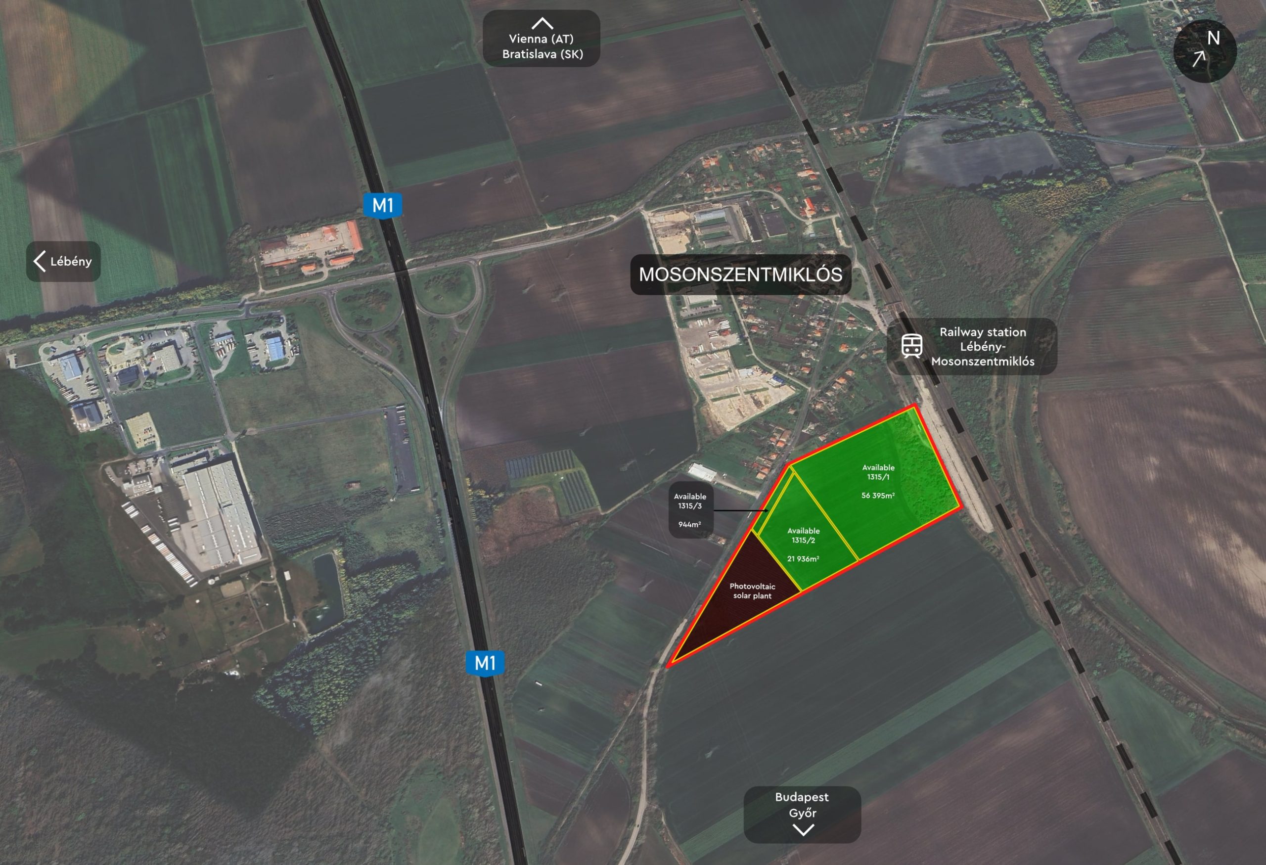
Distances to major points of interests by car
Available lots
No. 1315/1: 5.63 ha (56 395 m2)
No. 1315/2: 2.93 ha (21 936 m2)
No. 1315/3: 0.90 ha (944 m2)
Total available area: 7.92 ha (79 275 m2)
The lots can be purchased individually or jointly. A modification of the prevailing division of the lots is possible, after consultation with and approval by the seller.
The creation of lots smaller than 2 ha (20 000 m2) will not be approved by the seller.

7 000 m2


25%

50%
Description of the area
Archeological remains
According to the zoning plan and our experience to date, the lots are partly archaeologically affected.
Lot no. 1315/1 to an extent of approx. 25% of the area.
Lot no. 1315/2 and /3 to an extent of approx. 80% of the area; however these parcels have already been largely archaeologically explored and cleared.
Land designation
The area is located inside of the town of Mosonszentmiklós and constitutes “land intended for construction”. The levy for rezoning from agricultural use has been fully paid. A zoning plan is in force for the whole area, which has to be taken into consideration in case of construction:
Land designation: “Gip” – Commercial and industrial use
Max. degree of covered area: 50%, free-standing
Max. building height: 14 m
Min. green area: 25%
Min. lot size: 7 000 m2 (and min. 25 m width);
Due to the zoning plan in place an application for a building permit can be submitted immediately.
Infrastructure
The basic utilities such as electricity, water, sewerage, and gas can be found in the adjacent Béke street. The available and necessary capacities have to be evaluated individually with respect to the particularities of the specific project.
For the time being there is no rainwater channel. An optimal solution is to percolate the rainwater, for which the gravelly soil in place is most favorable.
Railway connection
The lots are directly neighbouring the railway track Vienna-Budapest and the local railway station Lébény-Mosonszentmiklós.
Soil conditions, contamination
The surface is almost perfectly level, which means that no significant landscaping is required for construction. The gravelly soil has a high bearing capacity; therefore, no expensive building foundations have to be expected.
The property has been used as agricultural land since time immemorial, therefore contamination can be ruled out. In the meantime, the land continues to be in agricultural use.
Errors and changes are reserved at all times. Liability is excluded. The pictures, visualizations and plans shown on the website/in the info-guide (pdf) may differ from reality.


